
“I came to think of being an explorer as an attitude, a way of life for those who have a keen interest in the world outside common experience; a way of life that is stamped with the seal of freedom and adventure.”
-- Ariane Audouin-Dubreuil, Crossing the Sands
Ensconced in our work-a-day world and bombarded by international media, it is very easy to believe that the world is known, that everywhere has been explored, and that we might as well just go to work and plug along at life. Sure, most of the first assents and initial crossings have been made, but as Ariane Audouin-Dubreuil states in her book about her father’s crossing of the Sahara by car, being an explorer is an attitude. There are places to explore everywhere, and even the seemingly known can provide a dramatic adventure for those willing to step out of the mainstream. Of course, the feeling of ‘being out there’ is often hard to capture in your backyard, and remote regions that force you out of your comfort zone only add to any adventure in the offing.
For most of my childhood I had been caught up in the drama of Africa and its wild places. Other parts of the world held little interest until much later, and one region never even registered on my radar until very late; Central America.
The Petén Basin of northern Guatemala is a dense rainforest; wet, wild and brimming with Mayan ruins, many known, but as yet un-excavated. At the height of the Mayan civilization (around 750 AD) it is estimated that two million people lived in the basin, making it one of the most densely populated regions on the planet. Today, the population is estimated at 450,000, most of which are packed into the triple cities of San Benito, Santa Elena and Flores to the south. The Petén is also home to the first UNESCO World Heritage Site at Tikal, and massive reserve called the Maya Biosphere Reserve. There are an additional 26 known Mayan sites and an estimated 30 still awaiting discovery. The Mayan city of El Mirador holds La Danta, one of the largest structures in the ancient world, and the largest pyramid complex in the Americas. In the northeast corner of the region lies Rio Azul, with the second largest pyramid in the Americas.
So, enough of the history. What would it be like to be a part of a small expedition into the Petén, to seek out the more remote and harder to reach ruins, to explore, not quite like Cortez did, but with the same sense of adventure? True, Tikal is one of the most visited sites in Central America, but all the tour busses stop there and turn back. None venture north into the jungle, and for good reason. The road deteriorates (or improves, depending on your view) to a track winding through dense undergrowth, cut in many places by fallen trees and floored by mud and water at times feet deep. Spider monkeys make aggression displays in the treetops, and forward progress becomes dependent on the machete, the chainsaw and the winch. Sheathed for centuries behind tangled layers of vines and spider webs, ruins appear out of the jungle like apparitions out of an Indiana Jones movie; but only to the practiced eye. Massive pyramids, still blanketed by the jungle, seem completely untouched. With no one around, you feel you could be the fist explorer to set foot in this place.
While my attention was consumed by Africa, it took some good friends to open my eyes to the possibilities of Central America. In April, 2011 I had the opportunity to assist James and Angela of No Limits Expeditions with a small expedition into the Petén Basin—beyond the hustling cabbies of Flores and tourist-packed buses at Tikal. While coordinating self-guided treks into the region are possible, hooking up with someone local, with intimate knowledge of the area, makes a lot of sense; not to mention they have fully-kitted vehicles in-country.
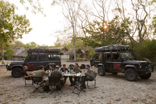
Our goal was reach Rio Azul and explore as many ruins as we could see along the way. With eight people, two Land Rover Defenders and a sense of adventure, it would not be an experience I will soon forget. Since pictures are worth a thousand words, I’ll let Ben Edmondson, photographer extraordinaire, continue with the story; I’ll just fill in some details. Travel with us . . .
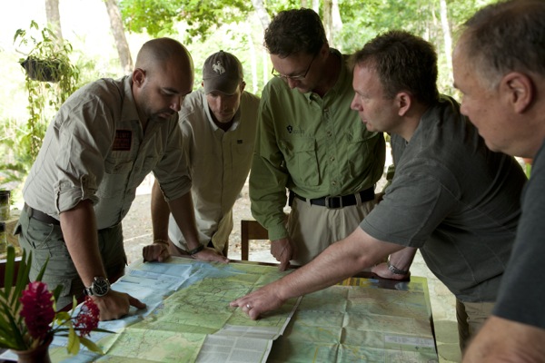
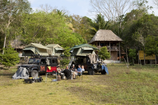
Expeditions take planning, and unfortunately maps of the Petén are vague at best. Here Eric, Mark and Pete get an overview from James and Graham on the planned route and the complication raised by the closure of our planned exit route. For some reason the Guatemalan government had recently closed the road south from Rio Azul.
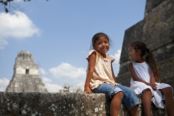
It’s Easter weekend and Tikal is abuzz with local tourists. These girls are sitting on a wall with Tikal Temple in the background. Permits have to be obtained at Tikal to enter the Biosphere Reserve and visit the sites deeper in the jungle. This is where we leave the tourist trail behind.
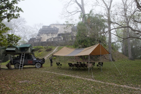
Our first camp, at Uaxactun, was magical and remained one of the group’s favorites of the trip. There were no tourists, only some masons working on one of the plazas. We parked the trucks and set up camp at the foot of one of the pyramids. In the morning, a light mist partially shrouded the edifice and surrounding jungle, adding to the mystery of the site. Dinner was served under an open-air awning; every seat with a window view of the pyramid. Uaxactun was rediscovered in 1916 by Sylvanus Morley, who gave it its present name.
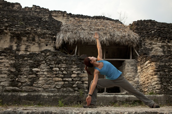
Alice managed to be the most active and stylish person on the expedition; here doing yoga on top of the pyramid at Uaxactun. When the mist lifted and the sun came through, the ruins were bathed in yellow light.
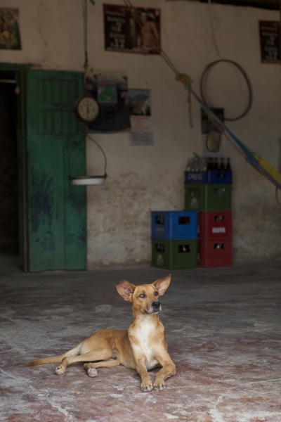
A nearby village is the only source of re-supply, and a quest for fresh water (and additional beer) took us to all the establishments in town. This dog was the most alert local we came across on a hot and lazy afternoon.
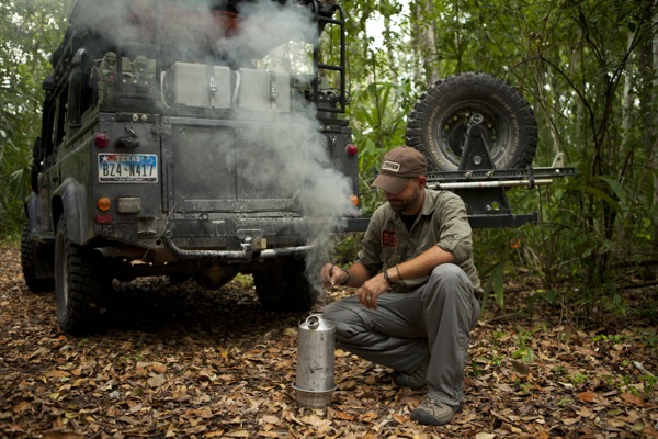
Heading north from Uaxactun the jungle gets more dense, while the cultivated land becomes more sporadic and eventually stops. Fallen trees crisscross the road, and forward progress slows. An afternoon stop for tea is a welcome break and a very British way to deal with the heat; here James uses the Kelly Kettle to brew.
Though we had no rain (amazingly enough!), evidence of what conditions would be like if it were wet were everywhere. Ruts swallowed tires, differentials dragged in the dirt, and the utmost care was needed to keep everything intact. Here I am trying to get James out of the ruts.
Alice (peering out of the window) takes in a Strangler Fig tree that has completely enveloped and killed its host. We stopped here for lunch.
Our waypoint for the next camp came from a fellow traveler, and proved to be a junction rather than the camp which was a further 12 kilometers along the track. That was unwelcome news at 4pm, but made arrival at El Cedro and the break in the jungle all the more appreciated. Park rangers here see in the region of 15 visitors a year; they were quite happy to see us.
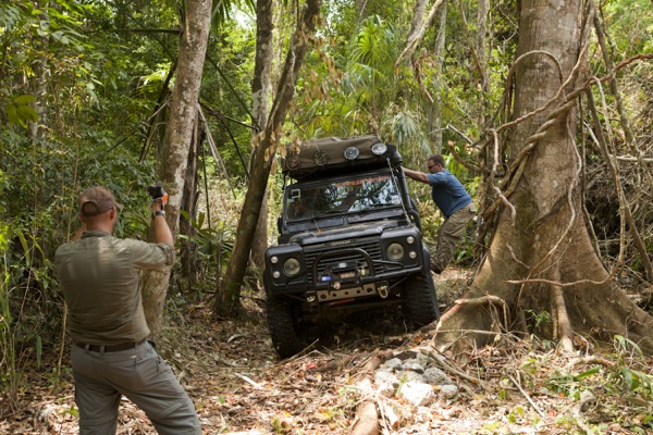
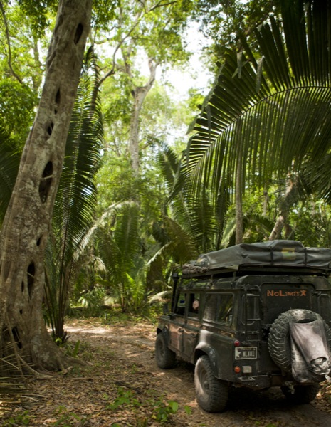
Roof top tents are easy targets for trees and low vines, making spotting a critical part of getting through the jungle. Mark adds some ballast to the passenger side as Eric follows James’ guidance through a tight section of trees.
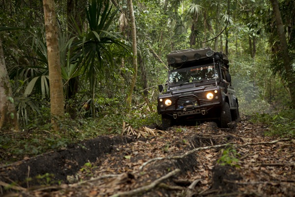
Long before reaching the Azul river, its reach becomes evident; ruts again swallow the grey Defender. It is almost impossible to keep out of them even in the dry. Often there is no choice but to follow them as the surrounding vegetation forces the vehicle’s path to its will.
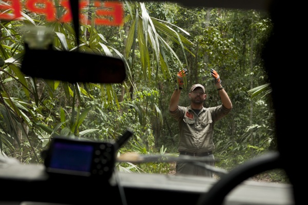
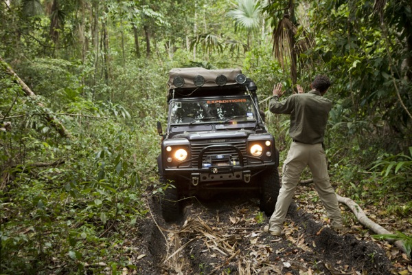
James directs forward progress while keeping a sharp eye on vines overhead. On this track we used the chainsaw half a dozen times, and the Woodsman’s Pals (machetes) all the time.
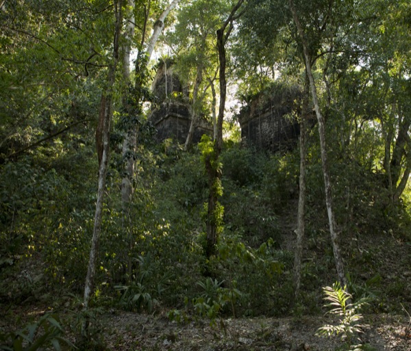
The pyramid complex at Rio Azul peers out of the jungle. Two pyramid peaks are visible on the main complex, and is the second largest of its kind in the Americas. Visitors are few and far between and we had the entire site to ourselves.
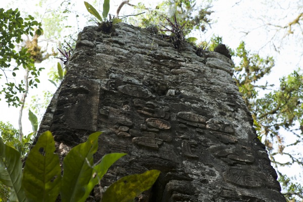
Intricate designs and carvings are still visible on the walls of many structures and speak to the eroding magnificence of what once was. When originally in use, the limestone base would have been coated with plaster and decorated.
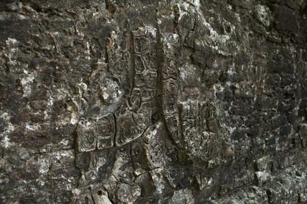
Rio Azul has 41 plazas and 752 structures (counted to date) in three square kilometers. Very little has been excavated, and murals and artifacts are not cordoned off.
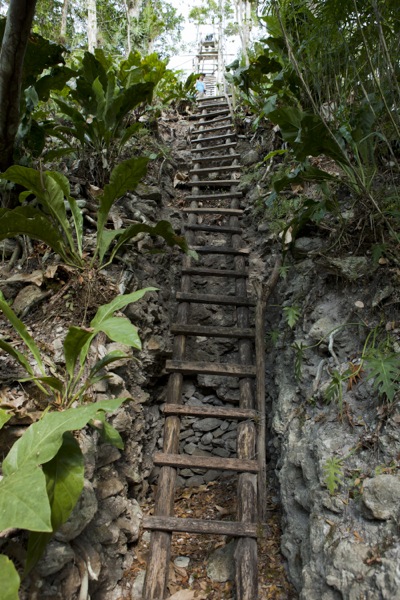
Footed in the crux of a robber trench, a wooden ladder rises to the top of tallest pyramid. The climb can be hair-raising.
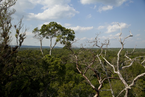
Rising 47 meters (155 ft) above the forest floor, the top of the main pyramid commands an imposing view over the jungle. Estimates are that 400,000 people lived in the area surrounding Rio Azul in 400 AD. From here their kings would have had a tremendous and uninterrupted view of their domain.
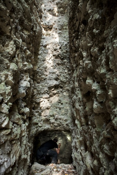
Far below the canopy at the pyramid base, robbers have dug massive troughs into the structure in search of artifacts. Eric ventures into one of these robber trenches. It is estimated are that 1,000 pieces of fine Mayan pottery leave the Petén every month bound for western markets and collections.
Due to security concerns with Mexican drug runners crossing the border close to Rio Azul, the rangers would not let us camp at the site. This is also why the road south had been closed. They did, however, offer us a pleasant berth at their camp where there was time to reflect on the wonders we had seen and contemplate future trips.
If ever you need a fast break from the drudgery of the everyday, a quick trip with any of the expedition outfitters like No Limit Expeditions can give you a medicinal dose of overlanding bliss.
|